THOROLD WELLAND LOOP (57 KM)
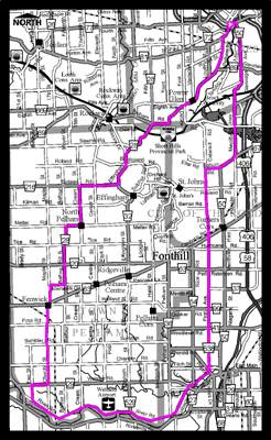
This 56.6 km route takes you past the Short Hills Provincial Park to the scenic Welland River road.
Dotted with many variety stores and restaurants nestled in small communities, this route provides the cyclist with a variety of Niagara’s tastes and attractions, including Maple Sugar farms,nurseries and stables, the famous “Comfort Maple”, Welland Airport, parks, Brock University, and ends with a descent of the Niagara Escarpment.
Thanks to the RNBC for providing this map.
CLICK HERE TO DOWNLOAD THIS MAP IN PDF FORMAT.
Some of the information presented on this site involves various routes and trails that many Niagara Cyclists use everyday. We can not take any responsibility for any accidents that may happen when using these routes. As always, ride responsibly!
Featured Community Builder
Featured Community Partner
In Support Of:
![]()
Niagara Cycling Categories
Below is a list of categories available through our Cycling Guide. Please click here to add your business to our listings.